Link to real time EDILSON Satellite Loop
http://tropic.ssec.wisc.edu/real-time/indian/storm/movies/MOV8-4.13S.GIF
Mauritius: A cyclone warning Class I is in force in Mauritius.
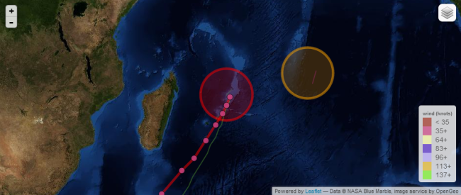
Reunion island: Unstable weather on the whole island. Moderate Tropical Storm Edilson 995 hPa, was located 640km to the north-east of Reunion island at 04H this morning with a southward movement at 9 km / h.
1. TROPICAL CYCLONE 13S (EDILSON) WARNING NR 001
   01 ACTIVE TROPICAL CYCLONE IN SOUTHIO
   MAX SUSTAINED WINDS BASED ON ONE-MINUTE AVERAGE
   WIND RADII VALID OVER OPEN WATER ONLY
    ---
   WARNING POSITION:
   050000Z --- NEAR 17.1S 59.5E
     MOVEMENT PAST SIX HOURS - 180 DEGREES AT 06 KTS
     POSITION ACCURATE TO WITHIN 030 NM
     POSITION BASED ON CENTER LOCATED BY SATELLITE
   PRESENT WIND DISTRIBUTION:
   MAX SUSTAINED WINDS - 040 KT, GUSTS 050 KT
   WIND RADII VALID OVER OPEN WATER ONLY
Tropical Cyclone ( TC ) 13S ( EDILSON ), located approximately 219NM North-east of Port Louis, Mauritius, has tracked southward at 06 knots over the past six hours. Recent animated infrared satellite imagery depicts formative banding tightly wrapping into a consolidating low-level circulation centre ( LLCC ). A 042018Z TRMM 37H, microwave image also reveals tightly curved banding over the eastern semi-circle wrapping into a well-defined LLCC. A 041717Z ASCAT, pass showed a 30 to 35 knot circulation with 40 knot wind barbs along the southern periphery, which supports the initial intensity assessment. Th initial position is based on the aforementioned microwave with high confidence. Upper-level analysis indicates the system is located south of the ridge axis in an area of low to moderate ( 10 – 15 knot ) vertical wind shear ( VWS ) and strong equator-ward outflow. TC 13S is forecast to track south- south-west ward along the western periphery of the subtropical ridge located to the south-east throughout the forecast period. After TAU 72, the combined effects of increasing VWS and cool sea surface temperatures will significantly weaken the system through the end of the forecast, leading to dissipation by TAU 120.
The general pattern of the system remains a monsoon low structure in the satellite imagery but the convection trends to wrap closer to the centre. On the other hand, the cyclonic curvature has accentuated and the observes pressure has still dropped ( 2 HPA since 1800z ). The low level centre is difficult to locate. Since morning, the system has slowly drifted generally southward. For the next hours. it should gradually resume on a south south-westward track over the north-western edge of the subtropical ridge and ahead of a deep mid-latitude trough located to the south-east of Madagascar.
Environmental conditions are good ( low shear, good upper level divergence on both sides ). Gradual intensification is therefore expected until Thursday. NWP models suggest that the structure could be a bit classical as the system will approach 20S. It is expected to maintain an asymmetric circulation with strongest wind and heavy rains mainly located within the south-eastern semi-circle. South of 20S, the northerly shear is expected to increase. Friday and Saturday, NWP guidances also suggest a positive interaction with the upper level dynamics associated with the mid-latitude trough that should persist to the south-east of Madagascar.
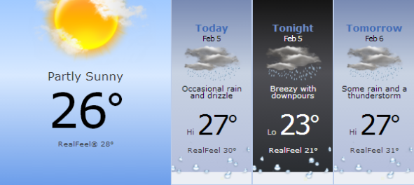
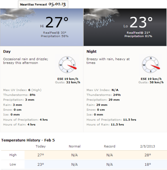
Mauritius 05.02.13, 24 hours cursory weather forecast.
IN REGARD OF TO THE EXPECTED TRACK,THE INHABITANTS OF THE MASCARENE ISLANDS (PARTICULARLY
MAURITIUS ISLAND WITH A TRANSIT EXPECTED TO CLOSER ON THURSDAY MORNING) SHOULD CLOSELY MONITOR THE PROGRESS OF THE SYSTEM.


Pingback: NetNewsledger.com - Tropical Cyclone Edilson Heavy Rainfall Recorded
Hello everybody, here every one is sharing these kinds of experience, thus
it’s nice to read this blog, and I used to pay a visit this website
all the time.
I do not even know how I ended up here, but I thought this post wwas great.
I do not know who you are but definitely you
are going to a famous blogger if you are not already 😉
Cheers!
Thanks 😉