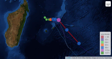
Maurice / Mauritius / Rodrigues / Agalega
A cyclone warning class II is in force in Mauritius.
Un avertissement de cyclone de Classe 2 est en vigueur a Maurice.
Reunion Island/ La Réunion
Alizé modéré de secteur Est.
Moderate East trade wind.
BANSI Current Status
Current Wind Speed 65 knots / MPH
Max Predicted Wind Speed 120 knots / 138 MPH at Tuesday, 13 Jan 2015 4:15 AM
Link to real time BANSI Satellite Loop
http://tropic.ssec.wisc.edu/real-time/indian/storm/movies/MOV8-4.05S.GIF
Forecast for this morning at 4hr15: Tropical Cyclone Bansi, located approximately 219NM North West of Po rt Louis, Mauritius, has tracked South-Southeastward at 04 knots over the past six hours. Animated enhanced infrared satellite imagery depicts a rapidly consolidating system with a 25 NM ragged eye.
Tropical Cyclone Bansi has rapidly intensified 35 knots over the past 24 hours from 30 knots to the current intensity of 65 knots. A 111611Z GPM 36 GHZ microwave image indicates a well organised low level circulation center with fragmented, multiple bands wrapping into the low level circulation center. Upper level analysis reveals a very favorable environment with dual channel outflow. There is high confidence in the current position based on the eye feature. The current intensity is based on DVORAK estimates of T4.0 (65 Knots)
From all agencies Tropical Cyclone Bansi is tracking slowly South Southeastward but is forecast to turn Eastward through TAU 36 as the near equatorial ridge shifts equatorward of the system. After TAU 36, Tropical Cyclone Bansi should begin to steer under the influence of the subtropical ridge positioned to the east and is expecting to maintain a southeastward track through TAU 120.
The dynamic guidance is in fair agreement supporting the general track, however, GFDN AND EGRR depict an unlikely East Northeastward track through TAU 36. In direct disagreement, satellite imagery through 111930Z continues to show a southward track motion. After TAU 36, dynamic guidance reflects similar track motion and synoptic steering environment.
Overall, there is low confidence in the JTWC forecast track due to the spread in model guidance. Tropical Cyclone Bansi is forecast to continue rapidly intensifying through TAU 48 to peak of 120 Knots due to very favorable outflow and warm SST (greater than 29C). After 48, environmental conditions will gradually deteriorate as SST and ocean heat content decrease to marginal levels.
Maximum significant wave height at 111800Z is 18 feet.

